Drone & Thermal Roof Inspections
Aerial and radiometric thermal drone inspections for Orlando commercial roofs — map trapped moisture under large low-slope membranes with zero foot traffic, flown FAA Part 107 with GPS-tagged documentation for claims and capital...
Some Orlando Roofs Are Too Big to Inspect on Foot
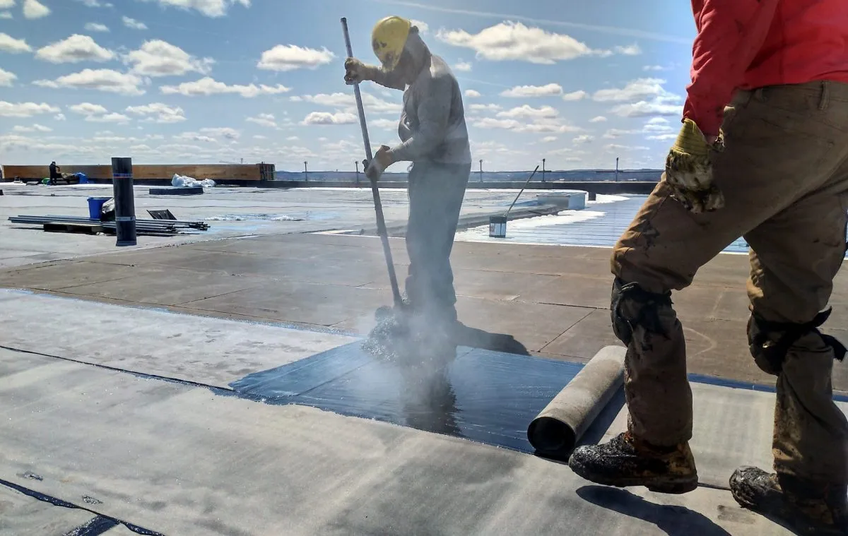
A 150,000-square-foot membrane is not a roof you walk — it is a roof you survey. Send two people across a distribution rooftop off the SR 528 Beachline near Orlando International, or the back half of a resort complex along International Drive, and they will burn most of a day and still only see what passes directly under their boots. On a hot Central Florida afternoon they are also pressing into a soft, sun-warmed single-ply sheet with every step, scuffing and risking the very surface they were hired to evaluate. We fly those roofs instead. A drone covers the whole field at a fixed altitude and consistent image overlap, finishes in a fraction of the time, and never makes contact with the membrane. For large low-slope commercial roofs, aerial is not a gimmick — it is the more accurate instrument.
We run two cameras on every survey, and they answer two different questions. The visual sensor maps the surface — seams, lap edges, flashing terminations, drain baskets, ponding rings, mechanical curbs, hail bruising, storm displacement — and stitches it into an orthomosaic you can zoom into down to an individual fastener. The radiometric thermal sensor maps what the surface hides. Between them you walk away with a complete, repeatable record of the entire roof instead of a sample, and that record is what every downstream decision rests on, from a single leak repair to a ten-year capital plan.
The Moisture Map Is the Whole Point
The most valuable thing a drone produces over an Orlando roof is not a pretty picture — it is a moisture map, and it runs on plain physics. Wet insulation stores far more heat than dry insulation. The roof bakes all day under the Florida sun; once the sun drops, dry areas dump that heat fast and go cool, while saturated zones hold it and glow on the thermal image well into the evening. Fly that cool-down window and the trapped moisture under the membrane draws itself out as sharply defined warm patches — water you would never find on foot, because nothing has leaked through to the deck yet. The membrane above it can look flawless while the insulation below is a swamp.
That one finding rewrites the entire scope conversation. A roof with a few discrete wet pockets is a cut-and-patch job. A roof with moisture creeping across a third of its area is a tear-off, because no coating or recover bonds to wet insulation and the trapped water keeps corroding the steel deck underneath it. We confirm the thermal hits with a handful of physical core cuts so the call is grounded in fact and not a heat artifact off a warm pipe, then hand you a map showing exactly where the water sits and how much of the roof it has reached. Specifying a reroof off real moisture data beats guessing, every single time.
Why Aerial Beats the Walkover Here
Coverage: the drone records the entire roof at uniform resolution, not just the lanes a crew happened to cross.
No foot traffic: nobody loads a soft, sun-heated membrane, so the inspection causes zero damage and carries no liability on an unknown deck.
Speed: a roof that eats most of a day on foot is flown in well under an hour — which matters across the multi-building campuses common around the airport and I-Drive.
FAA Rules, and Flying Inside Orlando's Airspace
Commercial drone work is regulated, and Orlando's sky makes that more than paperwork. Every flight runs under FAA Part 107 with a certificated remote pilot in command. A large share of the metro sits inside the controlled airspace tied to Orlando International and Orlando Executive, which means many sites require an airspace authorization before we can legally launch — and we clear that as part of scheduling, not as an afterthought on flight day. The temporary flight restrictions that flare up around major events and VIP movements in this market also have to be checked the morning of the survey, because one can shut a window with little notice.
On the ground we manage the same risk a roofing crew would, minus the rooftop exposure entirely. We keep the aircraft in visual line of sight, stay clear of anyone not part of the operation, and watch the wind and Central Florida's afternoon thunderstorms, which can build and scrub a summer flight window in minutes. None of this should be your problem to track — it is simply baked into how a survey gets booked and flown safely.
How Often a Roof Like Yours Gets Flown
One survey is useful. A repeated one is powerful. We generally fly a commercial roof twice a year — once in spring, once in fall — plus an extra pass after any serious storm crosses the metro. The spring flight catches whatever the previous storm season pried open; the fall flight confirms the roof is buttoned up before the next round of weather rolls in. Because every survey is captured the same way from the same altitudes, the imagery lines up cleanly year over year, and that consistency is what lets us show you change instead of just a snapshot: a blister that grew, a wet zone that crept outward, a seam that finally let go.
That cadence folds straight into a maintenance program. Each flight feeds a punch list of small fixes — a split pitch pan, a clogged drain, a lifted lap — that get handled before they become leaks, while the thermal pass flags creeping moisture back when it is still a patch instead of a replacement. For an owner running several buildings spread across the Orlando area, a recurring drone survey collapses a stack of disjointed contractor visits into one consistent, comparable record of every roof in the portfolio. It is about the cheapest insurance there is against a roof problem you never saw building.
Documentation an Adjuster and a Board Can Both Use
After a hail or wind event, the inspection has to produce something an insurer will actually accept. We deliver GPS-tagged imagery, hail-impact density maps, wind-displacement patterns, and tight close-ups of flashing and equipment damage, packaged the way commercial property adjusters expect to review remotely. Because every image carries coordinates and altitude metadata, the documentation holds up if a claim gets contested, and we can usually turn a post-storm package around within a day or two of flying it.
For owners and property managers who are not mid-claim, the same dataset feeds planning. A baseline survey today, repeated on a schedule, shows exactly how the roof is aging and where the next dollar should go — so a capital request is backed by imagery instead of a contractor's word and a hunch. Whether you are documenting storm damage on an I-Drive resort, scoping a repair on a West Colonial retail box, or building a multi-year budget for a campus near the airport, a drone and thermal survey hands you a clear, defensible picture of the whole roof. Get in touch and we will put a flight on the calendar for your Orlando property.
Keep comparing the scope.

Auto Dealership Roofing
Commercial roofing for auto dealerships, car lots, service centers, and automotive facilities throughout Orlando, FL.
Built Up Roofing
BUR assessment, targeted repair, recover, and replacement for aging Orlando commercial buildings — honest recover-vs-replace guidance with moisture...
Church and Religious Building Roofing
Commercial roofing for churches, worship centers, and religious facilities throughout Orlando, FL.